
Marshfield ZIP Code Directory Coverage
Official Massachusetts program tables list six ZIPs for Marshfield: 02020, 02041, 02050, 02051, 02059, and 02065. The list is a coverage check, not a claim that every address bearing a nearby postal label lies inside the town. Postal systems deliver mail. Parcel cards and recorded instruments establish different facts. Use the postal label to organize a search, then preserve postal city, municipality, neighborhood, and situs address in separate fields when records show more than one of them.
| ZIP | Areas covered | Post office | Notes |
|---|---|---|---|
| 02020 | Brant Rock and coastal Marshfield association | Confirm by exact address | Check the returned USPS delivery result |
| 02041 | Green Harbor association | Confirm by exact address | Green Harbor geography also reaches neighboring Duxbury |
| 02050 | Marshfield and central delivery area | Marshfield Post Office | Reviewed sources identify the post office as 02050-9998 |
| 02051 | Marshfield Hills association | Confirm by exact address | Neighborhood label is not a parcel boundary |
| 02059 | North Marshfield association | Confirm by exact address | Use the address, not the label alone |
| 02065 | Ocean Bluff association | Confirm by exact address | Coastal area has several village labels |
The six-code table gives useful local vocabulary. It cannot substitute for address verification. The Marshfield Post Office reference helps explain the broad 02050 label, while the other rows should be treated as common local or postal associations from the research, not fixed boundary descriptions.
Marshfield ZIP Code Delivery Geography
A ZIP is a delivery geography, not a legal town boundary. The official USPS lookup uses a street address, city, and state to return postal information for that address. It is the final postal check. A deed may name a municipality, the assessor may identify a situs address, and a Town Clerk record may use its own location wording. Keep all of those labels rather than forcing them into one field.
Green Harbor is the clearest local caution. Its postal and place name can occur across the Marshfield-Duxbury geography, so 02041 alone does not establish town. The same restraint helps with 02020 and coastal labels. The official sources reviewed did not show a current ZIP split or realignment affecting Marshfield's six-code list, and they did not provide a dated USPS boundary polygon. Check USPS again when a current delivery question matters.
Marshfield Coastal Postal Labels
Marshfield's coastal and village names add useful context to a ZIP code search. The master plan identifies Marshfield Center, North Marshfield, Marshfield Hills, Rexhame, Fieldston, Ocean Bluff, Brant Rock, Green Harbor, Sea View, and the coastal strip. It describes Marshfield Hills as a registered historic district around Main Street, Old Main Street, Pleasant Street, and Route 3A. North Marshfield is described around Union, Highland, and Oak Streets. The coastal areas have denser development and their own historic and planning vocabulary.
Beach references can help interpret an old address or select a map source. The police beach page identifies Rexhame Beach on Standish Street, Fieldston Beach at Hartford Road, Sunrise Beach at 9th Road, Brant Rock at Ocean Street and Dyke Road, and Green Harbor at Beach Street. A beach or village name is still not a legal address. Use it as a search term, then return to the full address, the assessor situs, and a dated record.
Historic maps add another layer. The Library of Congress has Marshfield Sanborn sets for 1916 and 1954, and the State Library lists coverage for 1933 through 1942. They can place streets and buildings within a historical village pattern. They cannot assign a modern postal value to an old printed address.
Search a Marshfield ZIP Code by Address
There was no direct ZIP search field visible in the inspected Patriot Properties form. Use the full-address method instead: confirm the postal result, search the street name in Patriot, then compare the assessor's situs, mailing city, parcel, neighborhood, and other fields. The town ArcGIS viewer can add parcel geometry, roads, and village context, but its live layers are a navigation aid rather than the authority for parcel or deed details. A dated Town Clerk response can be requested by year and street if the relevant public fields are available.
- Enter the complete street address, city, and state in the USPS lookup and preserve the returned ZIP and delivery city.
- Search the street name and optional street number in Patriot Properties to find the parcel and assessor situs.
- Compare the parcel in the town GIS for road, village, and map context.
- For a dated municipal list, request the year, street or address range, desired public fields, and preferred format from the Town Clerk.
- Label each result by source date and address type before comparing names or household information.
When the ZIP result has narrowed the area to a particular road, the Marshfield by-street directory contains the fuller address-record trail. ZIP filtering does not replace street-level parcel and registry work.
Marshfield ZIP Code Directory Search Fields
The address-first workflow uses different systems for different results. USPS validates delivery information. Patriot supplies assessment and parcel details. The GIS viewer supports map and parcel context. A Town Clerk request provides a dated municipal response if the public record exists and is available. The historic directory is a dated printed source, not current postal evidence. Keeping the input and limit visible makes the search easier to repeat and audit.
| ZIP-filter mode | Input | Output to preserve | Limitation |
|---|---|---|---|
| USPS address lookup | Street, city, state | ZIP, ZIP+4 if returned, delivery city | Delivery geography only |
| Patriot street search | Street name, optional number | Parcel, situs, owner, mailing, neighborhood, assessment fields | No direct ZIP field was visible |
| GIS map | Address, parcel, or map interaction | Layer, parcel geometry, road, village context | Live-layer date and controls were not stated |
| Town Clerk file request | Year, street, number, public fields | Dated street-list or census response | 2016–2021 links need field inspection |
| Historical directory | Year and street or section | Printed address and historical context | Not current ZIP evidence |
The assigned capture shows the live Marshfield Patriot Properties search form.
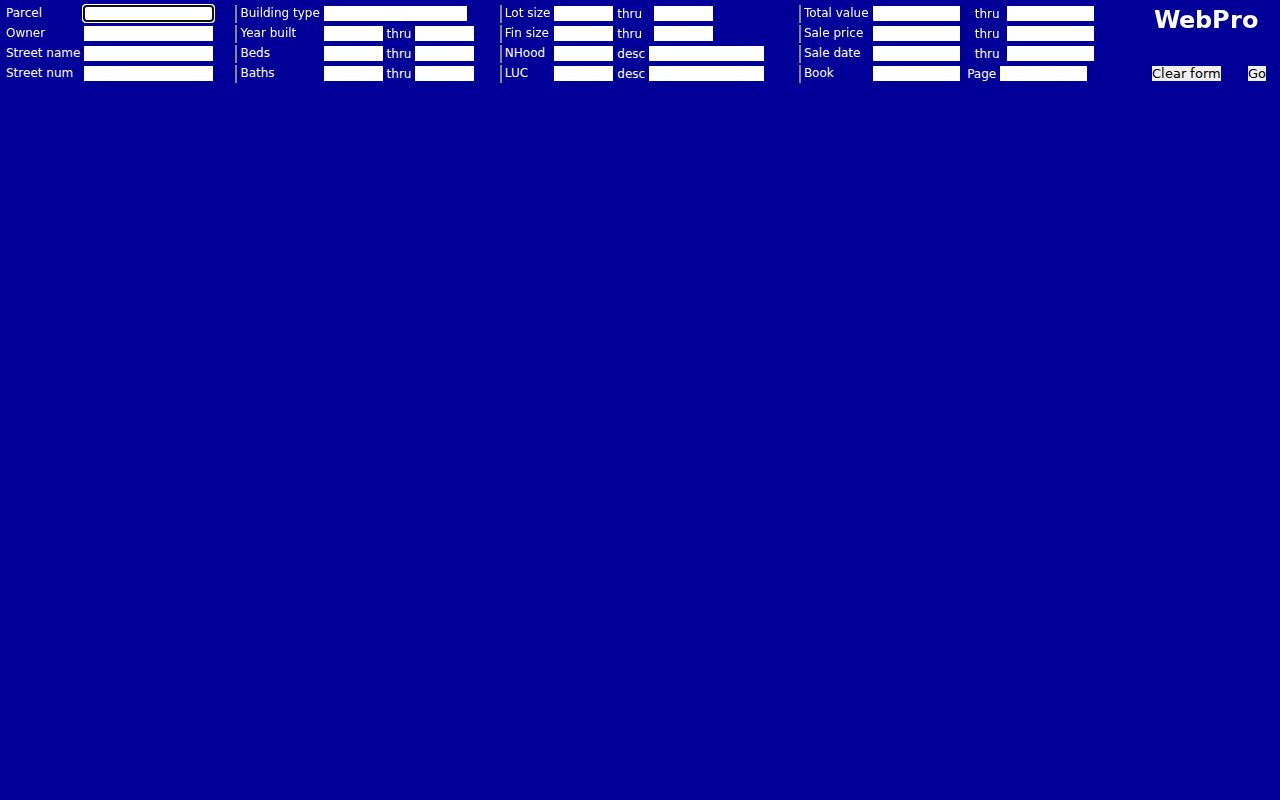
Its searchable parcel and street fields make it the municipal follow-up after a postal ZIP result, while TitleView remains the route for recorded instruments.
Marshfield Dated Postal Record Checks
The Massachusetts voter-status lookup accepts name, date of birth, and residential ZIP. Its output is limited to registration or pre-registration status, active or inactive status, polling-place, and representative information. It is not a ZIP-wide resident list. The stronger route for a dated public local file is a request to the Marshfield Town Clerk. Specify the election or annual-census year, precinct or town-wide scope, requested public fields, format, and whether a redacted sample is acceptable.
Public local voter lists can have different fields from the statewide central registry. Protected fields and confidential registration are not part of ordinary public use. Treat annual census or street-list files as separate local compilations until their titles, coverage, and disclaimers have been inspected. A ZIP can sort a query; the dated municipal record explains what the returned file actually represents.
Note: A residential ZIP is useful for a limited state status check, but it should not be used to construct a broad household history.
Marshfield ZIP Code Boundary Limits
ZIP boundaries, postal city names, neighborhoods, and town limits should be presented as different layers. The research specifically warns that an address can carry a postal city that differs from the municipality in a deed, the assessor situs, or a Town Clerk file. The official state table verifies the six-code Marshfield coverage list. USPS validates a deliverable address. The master plan supports neighborhood vocabulary. Assessor and GIS records provide parcel context. None of those records should be made to serve another custodian's role.
- ZIP code
- A delivery routing code used by the postal system; it is not a municipal border.
- ZIP+4
- An additional delivery detail that may be returned for a complete address.
- Postal city
- The city label used for delivery, which can differ from the municipality on a recorded or assessment record.
- Carrier route
- A mail-delivery grouping. It is not proof of a town boundary or a household relationship.
For 02050, begin with the Marshfield Post Office and a central-town address. For 02020 and 02041, check whether the Brant Rock or Green Harbor address is in Marshfield or a neighboring town. For 02051, 02059, and 02065, use Marshfield Hills, North Marshfield, and Ocean Bluff as local search vocabulary, then verify the complete address through the postal and municipal routes.
Marshfield Postal Record Context
A good postal record preserves its source and purpose. The assessor can show a parcel relationship, owner name, mailing address, sale lead, land-use classification, and assessment fields. The Registry can supply recorded land information, while older directories and Sanborn maps contribute historical place context. A mooring, seawall, shoreline project, beach access, or harbor permit is a separate coastal record. It should not be treated as a property ownership or current-address record without an independent source.
Coastal geography explains why labels can be rich but not conclusive. Rexhame and Fieldston have small-lot and seasonal-cottage history. Ocean Bluff and Brant Rock have shoreline development and coastal-protection records. Green Harbor combines village, harbor, wetlands, beach access, and fishing or boating identity. Use those facts to find the right map, plan, or municipal file. Preserve the precise program, year, and redactions when requesting a coastal record.